![]()
01246 922013
Principal: Steve Butler MRICS Chartered Surveyor
West Studios Sheffield Rd, Chesterfield, S41 7LL![]()
01246 922013
Principal: Steve Butler MRICS Chartered Surveyor
West Studios Sheffield Rd, Chesterfield, S41 7LL
We provide independent boundary dispute and right of way surveys throughout Chesterfield and North East Derbyshire. Our RICS Chartered Surveyors assist homeowners, solicitors and the courts with boundary identification, access disputes and expert evidence.
Our Chesterfield boundary dispute surveying services include boundary disputes, rights of way, Land Registry title plan interpretation and CPR 35 compliant Expert Witness reports.
Steve Butler MRICS has over thirty years’ experience dealing with boundary and right of way disputes in Chesterfield and the surrounding Derbyshire area. He regularly prepares expert reports for use in County Court proceedings. His legal training through the Chartered Institute of Legal Executives provides valuable insight where disputes involve both technical and legal issues.
Chesterfield Boundary and Right of Way Dispute Survey Report
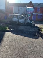
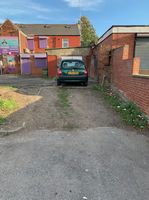
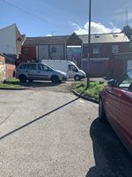
The claimant wanted to argue she had a right of way with a vehicle from a public car park through a splay that was persistently blocked by the land owner first with a car that was subsequently burnt out and then with bollards. Unfortunately, the judge found she had been using the splay for just short of the twenty years required for a right of way by prescription, she did not have a right of way by conveyance and that she had not acquired the right of way under Section 62 of the LPA 1925. It was found under cross examination that access to the splay had been blocked by a wall which was demolished less than twenty years ago and that an alternative access had existed at the time which had subsequently become blocked and then re-opened.


Boundary Dispute in relation to a hedge that was won by adverse possession
Our surveyor thought that the client had little going for her in trying to stop the neighbour removing a hedge but fortunately she had lived at the property for seventy years and was able to offer evidence that her father had planted the hedge and that the family had maintained it since.
Steve Butler has prepared boundary and right of way dispute reports for over twenty years. His experience includes preparing CPR 35 Expert Witness reports, attending court to give evidence, acting before the Land Registration Tribunal and providing binding boundary determinations where parties wish to avoid litigation.
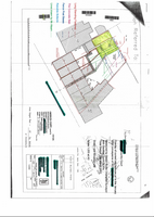
Many boundary disputes can be assessed using traditional measurement methods. In more complex cases, advanced surveying equipment may be required. We use Total Station laser surveying equipment to accurately record the position of site features and their relationship to one another. The data can be processed using CAD software to produce accurate plans, which may be overlaid onto historic conveyance documents where appropriate.


Conveyance documents showed no right of way existed and the OS sheet that an alterntaive right of way existed.
A boundary or right of way opinion must be supported by both physical evidence and legal understanding. Steve Butler has a working knowledge of land law, contract law and tort, together with relevant statutory provisions that commonly arise in boundary disputes.
Legislation frequently encountered includes the Prescription Act 1832, the Law of Property Act 1925 and the Land Registration Act 2002. There is also a considerable body of case law. Relating to boundaries. Without an understanding of the legal framework, it is difficult to produce a clear and reliable expert report suitable for court use.
RICS Chartered Surveyors Expert Report on a right of way and parking dispute
Our Expert Witness Surveyors look at badly laid out Yellow Lines, clamping signs and whether a access road is a private right of way or public highway
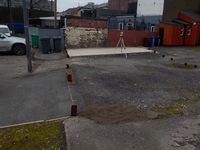
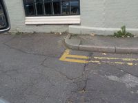
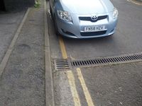
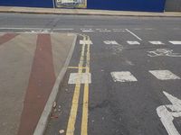
The dispute was about a parking ticket issued for 'Parking on the yellow lines in a restricted zone on Full Street' a public highway. The road is in fact an access to a service yard off Full Street. Steve Butler Chartered Surveyors argued for the recipient of the ticket that the car was on a private right of way and not the public highway. The City argued that the highway ended at a gully that runs across the road marked the end of the highway. Steve Butler Chartered Surveyors argued that if the gully was a juncture of public and private highway that there should be a T bar to mark the distinction and that gullies have no place in highway law. There was also a ‘no parking or you will be clamped sign’ on a car park wall just in front of where the car was parked. The City Council argued that the signs had not been put up by them despite their distinctive logo and that they owned the car park. A clamping sign on building on the opposite side of the road way was approximately mid-way between two T bars that stretch beyond where the car was parked. Our expert surveyors argued that the T bar at back of the pavement would be considered by a reasonable member of the public to be the end of the highway and that the section of road between the two T bars would be considered to be private as the clamping sign was at the centre. Full Street was considerably altered in the early 1970's to make way for the Assembly rooms redevelopment. We asked for a copy of the Full Street adoption order. Derby City Council will do anything but provided copy!
Surveyor's RICS CPR 35 Expert Court Report on a Chesterfield boundary dispute
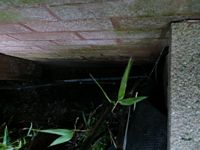
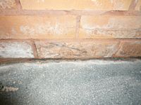
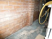
Here our clients were accused of having used a neighbours garage as a retaining wall for their patio. Our surveyor was able to show that the patio was separated from the garage by a gap extending to below the garage damp proof course level. The surveyor's CPR35 compliant expert witness report can be seen if you follow the link


This concerned a pair of semi detached houses that were not touching. They had both extended over their garage areas so as to be almost touching. One of them trying to alter the boundary so as to be able to access the gap between them. The available conveyance plan was unhelpful as it was very vague. Fortunately there was an almost complete set of ancient boundary posts in the rear garden and the conveyance plan was clear as to responsibility for the original wall separating the front driveways.
The case rasied an interesting although periphery question of law. Was the brick post shown constucted on the low wall an act of Adverse Posession or an Easement for Support? The Judge has yet to rule.
BOUNDARY SURVEY REPORT IN RESPECT OF THE BOUNDARY BETWEEN A HOUSE AND NOW SEPERATE DEVELOPMENT PLOT.


This concerned a plot of land adjacent to a semi detached house. The land had once belonged to the house and had been sold as a development plot in about 2006. The purchaser of the land had started to construct a fence along the side of the path that lead to the house as per planning application and with full knowledge of the vendor who still owned the house at that time. The development was then abandoned, but a new owner of the house from 2009 moved the fence to a line that appeared to be randomly chosen. The movement of the fence limited the size of house that could be developed on the plot and the dispute went to trial. The owner of the development plot was somewhat over confident and failed to appoint a barrister until hours before the trial. The barrister was all at sea. The judge had originally suggested that the fence at the side of the path was correct but was persuaded to side with the new house owner. The judge seems to have been much persuaded that the conveyance plan of the development plot might exclude a demolished coal store and that the coal store was accessed from the house.
All boundary dispute and right of way surveys are undertaken independently. We do not act for estate agents, developers or insurers and do not pay referral fees. Our reports are impartial, evidence-based and prepared in accordance with RICS guidance and CPR 35 requirements.
![]()